
Traffic
Сrеdit gоеs to !
Cities: Skylines II individually tracks the passage of every vehicle through your city’s road system. These include service vehicles, citizens’ private transportation, and freight.
It is important to manage the flow of traffic on your roads, as a blocked road causes delays in services reaching certain areas, and an increase in noise pollution.
In Cities: Skylines II agents choose a route based on a pathfinding cost. This cost is calculated using multiple factors such as the city’s road network, traveling time, travel cost, agent preferences, and more which we will cover in more detail below.
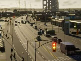
Significant traffic on multi-lane roads

Furthermore, agents will adjust their route based on events along the way. They may change lanes to avoid a car accident or a stopped service vehicle or make room for a vehicle responding to an emergency.
Route Selection
The core of pathfinding calculations is the four aspects: Time, Comfort, Money, and Behavior.
Time is the foremost factor for Adult citizens. While other factors affect pathfinding, time is usually the most important as all agents tend to seek the quickest route to their destination. When considering only the travel time, a small road can be shorter but its travel speed is lower than the longer highway’s travel speed so the agent chooses the highway in most scenarios if the highway is overall a quicker route.
Comfort is the foremost factor for Senior citizens and includes planning the route to be as smooth as possible, avoiding unnecessary turns at intersections as well as finding a suitable parking spot or public transport stop to get off at. Comfort is calculated directly to the pathfinding cost with each option adding to the overall cost.
Money is the foremost factor for Teen citizens and comes into pathfinding choices in the form of fuel usage and potential parking fees. Citizens weigh travel and parking costs and compare them to other travel options as well as walking to see which option is quick, comfortable, and affordable. In the case of delivery vehicles, the cost of resources they transport increases the further away they are delivered. As a result, selling resources and goods locally is more cost-efficient for the companies as the delivery costs are lower than hauling the cargo to an outside connection.
Behavior refers to agents’ willingness to make “dangerous” decisions in traffic, such as making a U-turn. Citizens and delivery vehicles are less likely to make dangerous decisions in traffic to cut pathfinding costs, while emergency vehicles have a more lenient behavior model so that they can navigate the road network during emergencies and make dangerous pathfinding decisions if necessary and they are able to make illegal U-turns if it shortens their route to their destination. If possible, other vehicles will give way to the emergency vehicles by switching lanes on multilane roads.
Service vehicles are ordered based on the lowest overall pathfinding cost and when new orders are made, they take into account the distances of all applicable vehicles now and in the near future (as in: where will the vehicles end up after they have fulfilled their previous service order). As an example, a road maintenance service vehicle is ordered to repair a road segment.
The simulation checks where all available vehicles are at the moment and where their current orders are taking them. A currently closer vehicle might not be selected for the new order if another vehicle is on its way to a nearby location shortly as it finishes its current service order.
Resource transportation is affected by the length of the route as distance increases the costs, so companies try to ship cargo as close as possible to increase their own profit margin. Transporting resources and goods out of the city is costly and can greatly decrease the profitability of companies.
Traffic Accidents
Traffic accident

Cities: Skylines II features traffic accidents where vehicles lose control and crash into traffic or buildings. The likelihood of an accident happening is calculated per road segment and is increased by features such as road conditions, lighting conditions, weather, and disasters. Keeping roads in good condition by using road maintenance services and having streetlights is a good way to decrease accident probability on the road.
When an accident takes place, a vehicle on the segment will lose control and be pushed in a random direction. Collision physics allow it to hit any obstacle on the way, and if a vehicle collides with another vehicle it may start a chain reaction.
Accident sites need to be secured and cleared by the police and road maintenance, respectively. Traffic will be blocked on the lanes that are affected by the accident, potentially blocking the road if all lanes are blocked.
Ambulances might also be called to the site if the accident was severe enough to cause serious injuries. If clearing the site of the accident causes traffic jams for a prolonged period, agents might recalculate their pathfinding and make U-turns to find alternative routes circumventing the blocked lane.
Intercity Traffic
Cities: Skylines II also features traffic between other cities, from one outside connection to the next. This traffic does not contribute to the city’s economy but the traffic can become part of the overall traffic flow as the city grows and the highways are integrated into the city’s road network.
If the player builds a shorter route between two outside connections, the traffic between those cities will change to use the newly created option if it is more cost-efficient in regard to pathfinding.
Finding Traffic
Traffic info view

Roads with heavy and/or congested traffic can be observed visually, simply by looking at the flow of vehicles on the roads. Long tailbacks will be fairly obvious. Watching the flow (or lack thereof) of traffic at a junction or intersection can provide clues as to the cause, and solution, of a given traffic flow problem.
Additionally, Cities: Skylines II has a traffic info view. Clicking it overlays a gradient of green to red on the roads, depending on the density of the traffic in the area. Heavy traffic (red areas) are not necessarily problem areas in terms of traffic flow; a well designed road system will have the capacity to deal with its zones of high demand.
An “Average Traffic Flow” rating for the whole city is also displayed in the form of a percentage. A higher percentage indicates better traffic flow. A second info view can be accessed with the Traffic Routes button. Clicking on a road or path with this selected in the “Routes” tab will show all of the traffic currently planning to pass through there. The “Junctions” tab allows for the toggling of traffic lights and stop signs.
The final tab, “Adjust Roads”, allows for the player to adjust what is considered one road, which is based on its name. A green line will appear to highlight the road, with dots on either end that can be dragged to adjust the road. There will also be a dot between the endpoints on the road segment that was clicked on. Either endpoint cannot be dragged past that dot. Click on another road segment located on the line to move this dot.


Be the first to comment